
CSRS-PPP Updates and Information
Beginning with GNSS observations collected on Sunday, 27 November 2022, CSRS-PPP will output ITRF solutions in the IGS20 reference frame. This new reference frame is the International GNSS Service (IGS) realization of ITRF2020. For more information on the IGS20 reference frame, please see the IGS20 release announcements.
What will change in CSRS-PPP beginning 27 November?- All IGS products beginning on this date will refer to the IGS20/ITRF2020 reference frames.
- The product names will follow the IGS long filenames standard. Specifically, for products starting on 1 January 2018, CSRS-PPP will use and report in the SUM file products based on the following nomenclature:
- DCU: Hourly ultra-rapid products (EMR0DC[A|B]ULT_*)
- DCR: Daily rapid products (EMR0DC[A|B]RAP_*)
- DCF: Daily final products (EMR0DC[A|B]FIN_*)
- CSRS-PPP will adopt the new IGS20 absolute antenna calibrations.
Where "A|B" refers to the internal server which generated the product and "ULT|RAP|FIN" indicates the product line.
The only change to CSRS-PPP solutions for observations collected prior to 27 November 2022 will be a switch to the IGS long filenames for products beginning on 1 January 2018.
What will be the impact on user solutions?The switch to IGS20 products will impact user solutions due to:
- The reference frame change from ITRF2014 to ITRF2020 (ITRF users only);
- GNSS antenna calibration updates from igs14.atx to igs20.atx; and
- Update of some IGS conventions and models.
Please see IGSMAIL-8238 for details.
How can you access help?If you have questions or encounter issues that require assistance from CGS staff, please contact us by email.
Beginning Friday, March 26, 2021, the CSRS-PPP service will automatically decimate high-rate static datasets to a data rate of 30 seconds. This will affect only dual-frequency, static datasets containing both code and phase data for which at least 75% of the expected 30 second intervals are available. For all other data sets, there will be no impact.
What are the benefits to automatically decimating high-rate static data sets?Automatically decimating high-rate data sets in static mode has benefits for the CSRS-PPP service, as well as the user. These include:
- Significantly reducing the processing time for each submission, allowing users to receive their results quicker while also reducing the amount of computing resources required.
- In static mode, processing data at rates higher than 30 seconds does not improve the accuracy of the solution. In fact, for short data sets it can actually reduce the accuracy. This is because CSRS-PPP uses precise GNSS clock products at a 30-second rate.
The following results show the RMS of the differences between CSRS-PPP and daily IGS estimated positions, for different observation session lengths (30 min, 1h and 24h), processed in static mode at 30 s and 1 s observation intervals.
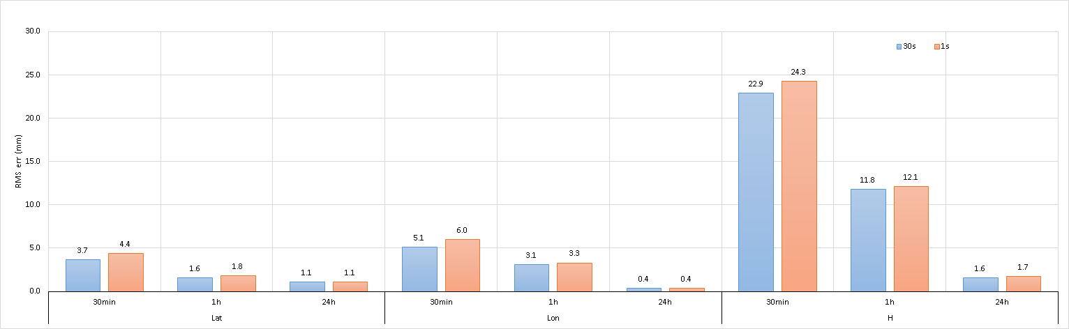
17 CACS files (30min-1h-24h obs) - SPARK v3.45.0 - AR - Static mode - GNSS (GPS+GLONASS)
The Canadian Geodetic Survey (CGS) of Natural Resources Canada (NRCan) updated the Canadian Spatial Reference System Precise Point Positioning (CSRS-PPP) service on Tuesday 20 October 2020. This CSRS-PPP modernization includes PPP with ambiguity resolution (PPP-AR) for data collected on or after 1 January 2018. At the same time, there will also be updates to CSRS-PPP outputs.
What are the benefits of PPP with ambiguity resolution (PPP-AR)?
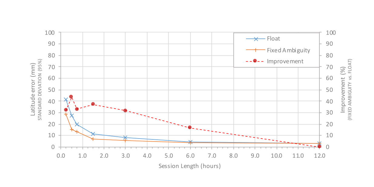
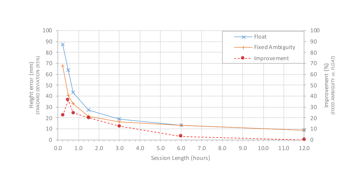
Ambiguity resolution offers significant benefits for users by transforming ambiguous carrier-phase observations into precise ranges. As a result, centimeter-level accuracies can often be obtained more rapidly. Furthermore, due to satellite geometry, resolving carrier-phase ambiguities results in improved estimates for the longitude (east) component.

Who can benefit from PPP-AR?
Dual-frequency GPS data collected on or after 1 January 2018 can be processed with PPP-AR using the new products of NRCan. Data collected before this date will continue to be processed in float mode using the International GNSS Service (IGS) products.
Why will data collected before 1 January 2018 not be processed with PPP-AR?
New PPP-AR-capable products are, for the moment, only available for data collected on or after 1 January 2018. Prior to this date, there were not enough analysis centers that provided satellite phase biases consistent with satellites' orbits and clocks; these biases are required for ambiguity resolution.
New features
The main novelty of CSRS-PPP version 3 is the implementation of PPP-AR algorithms. Apart from this substantial change, other modifications could impact results with respect to CSRS-PPP version 2; a tutorial is available to describe these modifications.
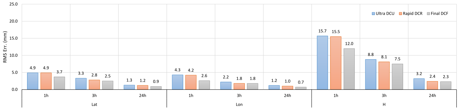
NRCan is also now generating new PPP-AR-capable products with improved latencies:
- DCU: Hourly ultra-rapid products available about 60 minutes after the end of each hour. Note: Both GPS and GLONASS orbits are now available with the same latency.
- DCR: Daily rapid products available about 12 hours after the end of each day.
- DCF: Weekly final products available about 12 days after the end of each week. Includes GPS satellite orbits from the IGS, NRCan final GLONASS orbits, and an NRCan final clock combination.
What will be the impact on users?
- Submission interfaces and input options will not change
- Some outputs will change:
- Information on the percentage of fixed ambiguities, as well as a new ambiguity status plot will be added to the solution report (.pdf)
- The percentage of fixed ambiguities will be reported in the '.sum' file under the tag "IAR"
- The tropospheric zenith delay and receiver clock estimates will be moved from the '.pos' file to the '.tro' and '.clk' files, respectively
The new CSRS-PPP outputs
Information detailing the file formats for all new and updated output files are provided in advance, allowing you to familiarize yourself with the new outputs.
- A solution report (.pdf) presenting the PPP results in a combination of textual and graphical information. For report descriptions, see:
- A summary file (.sum) which contains the parameters and the results of the PPP processing in (a machine-readable) text format. See summary description.
- *UPDATED for version 3* A position file (.pos) containing the positioning information for each epoch processed. See updated position file description.
- *NEW for version 3* A tropospheric zenith delay file (.tro) containing dry and wet zenith path delay and tropospheric gradient for each epoch processed. See tropospheric zenith delay file description.
- *NEW for version 3* A RINEX_CLOCK format file (.clk) containing the receiver clock offset and the clock offset sigma (95%) for each epoch processed. See clock file description.
- A comma-separated format text file (.csv) containing the positioning and clock information for each epoch processed.
- A JSON format residual file (.res) containing the solution residuals for each epoch/signal pair. See residual file description. Note that a tool to transform residual files from JSON format to text (ASCII) format is available here.
- An error file in text (.txt) format containing any errors or warnings from the processing.
Sample output files:
Static solution, Kinematic solution, Residual fileHow can you access help?
If you have questions or encounter issues that require assistance from CGS staff, please contact us by email.
We look forward to providing an improved positioning service with this new version.
Use of Canadian Geodetic Survey products and data is subject to the Open Government Licence - Canada
- Date modified: